Olympic Coast National Marine Sanctuary Boundary Map
Olympic Coast National Marine Sanctuary consists of an area of approximately 3,188 square miles along the coast of Washington state's rugged Olympic Peninsula. The sanctuary shoreline measures approximately 135 miles, and borders Olympic National Park, Washington Island National Marine Refuge Complex, reservations of the Makah, Quileute, Hoh Indian Tribes and the Quinault Indian Nation. In addition, the sanctuary borders approximately seven miles of the Washington State Seashore Conservation Area.
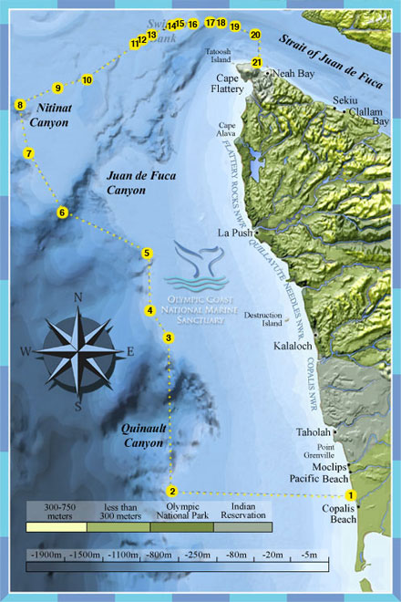
Bounary Coordinates
[Based on North American Datum of 1983]
| Point | Latitude | Longitude |
|---|---|---|
| 1 | 47° 07.75' N | 124° 11.03' W |
| 2 | 47° 07.75' N | 124° 58.20' W |
| 3 | 47° 35.08' N | 125° 00.00' W |
| 4 | 47° 40.08' N | 125° 04.73' W |
| 5 | 47° 50.02' N | 125° 05.70' W |
| 6 | 47° 57.22' N | 125° 29.22' W |
| 7 | 48° 07.55' N | 125° 38.33' W |
| 8 | 48° 15.00' N | 125° 40.90' W |
| 9 | 48° 18.35' N | 125° 30.05' W |
| 10 | 48° 20.25' N | 125° 22.88' W |
| 11 | 48° 26.77' N | 125° 09.28' W |
| 12 | 48° 27.15' N | 125° 08.50' W |
| 13 | 48° 28.14' N | 125° 05.87' W |
| 14 | 48° 29.72' N | 125° 00.18' W |
| 15 | 48° 29.94' N | 124° 59.32' W |
| 16 | 48° 30.22' N | 124° 54.95' W |
| 17 | 48° 30.35' N | 124° 50.43' W |
| 18 | 48° 30.17' N | 124° 47.30' W |
| 19 | 48° 29.61' N | 124° 43.64' W |
| 20 | 48° 28.13' N | 124° 38.22' W |
| 21 | 48° 23.28' N | 124° 38.22' W |