Oceanography
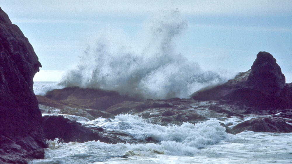
The Olympic Coast is known for its rough seas and large waves. Extreme wave heights up to 49 feet have been recorded on and beyond the continental shelf. Winter storms travel across the fetch of the Pacific Ocean and the energy is magnified as they encounter the shallower continental shelf, where their force pounds the coast with gathered intensity.
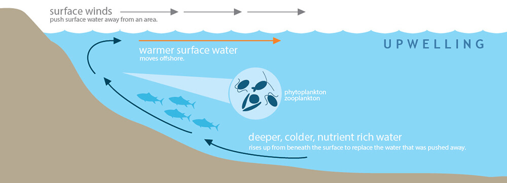
Surface winds generated by atmospheric pressure systems are the main force driving ocean surface circulation off the Pacific Northwest and produce two distinct ‘seasons’ that are tightly associated with regional productivity and energy flow. Spring and summer winds generally blow from the north and push surface waters southward and offshore, resulting in nearshore upwelling of cold, nutrient-rich water to the surface. This influx of nutrients enhances plankton communities that support the region’s productive fisheries. Downwelling tends to occur in the fall and winter months, when the winds generally blow from the south, forcing surface water into the subsurface. Other physical features also play a role in these dynamics, including shelf platform width, river plumes, submarine canyons, banks, coastal promontories, and offshore eddies. These geographic features influence the retention, magnitude, and timing of nutrient delivery to plankton and may explain why primary productivity is higher along the Washington coast than the Oregon coast.
On a regional scale, the California Current transports cold, subarctic water southward from British Columbia along the Washington coast to Baja California, directly influencing the local distribution of marine organisms. The California Current generally occurs from the continental shelf break to a distance of about 600 miles from shore and rides above the narrower California Undercurrent, which flows northward and is implicated in the transport of larvae and other plankton. The California Current and Undercurrent are strongest in the summer, while the seasonal, nearshore Davidson Current flows northward during winter months, transporting the Columbia River plume along the Washington coast. Another local feature, the Juan de Fuca Eddy, which is approximately 30 miles in diameter and located offshore of the mouth of the Strait of Juan de Fuca, persists in summertime and entrains nutrient-rich, cold water in a counterclockwise circulation pattern.
Oceanic and atmospheric events across the Pacific basin influence the waters off the Olympic Coast. For example, the El Niño Southern Oscillation is primarily driven by sea surface temperature in the Equatorial Pacific Ocean, but is a major source of interannual climate variability in the Pacific Northwest, with events lasting six to 18 months. El Niño periods generally produce lower chlorophyll and higher sea surface temperature, while La Niña years produce high chlorophyll and low sea surface temperature. During an El Niño phase, storms have also created erosion hotspots. Similarly, the Pacific Decadal Oscillation is a dominant driver of climate variability in the Pacific Northwest, where warm or cool phases can each last 20 to 30 years. Warm Pacific Decadal Oscillation phases correlate with diminished upwelling along the California Current. Positive Pacific Decadal Oscillation phases result in warm temperatures and higher sea level. The phase of El Niño Southern Oscillation and Pacific Decadal Oscillation may also reinforce or weaken the climatic effect of each phenomenon. Climatic cycles such as these are natural events and are often associated with strong fluctuations in weather patterns and biological resources.
References
Ruggiero, P., Kratzmann, M. G., Himmelstoss, E. A., Reid, D., Allan, J., & Kaminsky, G. (2013). National assessment of shoreline change: Historical shoreline change along the Pacific Northwest coast. Open-File Report 2012–1007. U.S. Department of the Interior, U.S. Geological Survey.
Hickey, B. M., & Banas, N. S. (2003). Oceanography of the U.S. Pacific Northwest coastal ocean and estuaries with application to coastal ecology. Estuaries, 26, 1010–1031.
Hickey, B. M., & Banas, N. S. (2008). Why is the northern end of the California Coastal Current system so productive? Oceanography, 21(4), 90–107.