Geology
Olympic Coast National Marine Sanctuary is located within a region known for dynamic plate tectonics that have shaped marine and terrestrial habitats and continue to affect the sanctuary in a geologic context. Earthquakes, tsunamis, and massive glaciers have shaped the landscape over time, isolating the Olympic Mountains to produce endemic species, carving submarine canyons and coastlines, and depositing boulders and other glacial moraines on the adjacent continental shelf. Efforts to better understand the region’s geologic past continue to inform contemporary research efforts, including seismic testing of active submarine faults associated with a 700-mile subduction zone offshore; understanding differential vertical shifting of land on the Olympic Peninsula relative to sea level; mapping for hazard planning and modeling; and development of tsunami inundation maps and alert systems for residents and visitors to the region’s coastal areas.
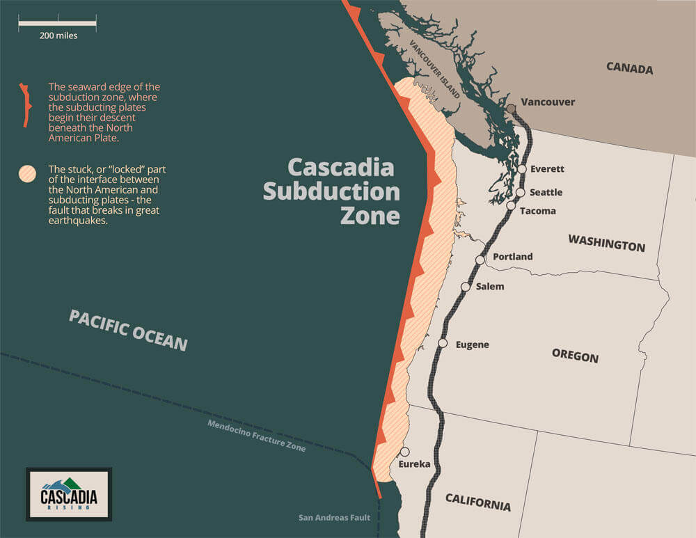
The Olympic Coast is subject to tectonic forces caused by the combined movements of the large Pacific and North American Plates and the smaller Juan de Fuca Plate. The Juan de Fuca Plate and the Pacific Plate are spreading away from each other at a divergent plate boundary offshore, with the Juan de Fuca plate being pressed toward and beneath the North American Plate. The area encompassing this activity is known as the Cascadia Subduction Zone (Figure 1). These forces have produced a chain of volcanoes within the uplifted Cascade Range. The geologic activity in the area off the Olympic Coast gives rise to potential hazards such as earthquakes and associated submarine landslides, tsunamis, and volcanic eruptions.
Due to geological forces, the northern portion of the Olympic Peninsula is experiencing vertical land movement (uplift), which results in low relative sea level rise compared to the southern portion of the sanctuary, where relative sea level rise is more pronounced. Plate tectonics, and to a lesser extent isostatic rebound of land following glacial melt, are the driving forces in this vertical land movement.
The Cascadia Subduction Zone is capable of generating a magnitude 9 or higher earthquake and resulting tsunami. Such a large magnitude earthquake could significantly impact remote communities on the Washington coast within a few minutes and affect major cities throughout Puget Sound soon after. Places like Neah Bay that are currently experiencing vertical uplift are at risk of significant subsidence following an earthquake, and may experience slumps and drops of up to 6 feet.
The sanctuary seafloor is a rich and varied component of the marine ecosystem (Figure 2). The glacial landscape that has been submerged for the last 10,000 years contains deeply eroded canyons, rocky shorelines, and scattered boulders, along with glacial ridges and vast, uninterrupted sand and mud plains. A continental shelf reaches 8–40 miles out from Washington’s coast and provides a relatively shallow 660 feet in depth or less) coastal environment within the sanctuary. Unconsolidated, soft-bottom sediments comprise the majority of habitat in the sanctuary. Several submarine canyons cut into the continental shelf along the western boundary of the sanctuary, and the Strait of Juan de Fuca flows into the trough of the Juan de Fuca Canyon in the northern portion of the sanctuary.
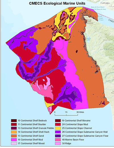
Submarine canyons act as channels for coastal sediment to reach the deep seafloor; enhance upwelling by providing deep, cold, nutrient-rich water to the surface; and support a diverse community of species living on the deep seafloor. In the northern portion of the sanctuary, sediments on the shelf are largely glacial deposits from the Ice Age, and the shelf slope is steeper and more jagged. Additional sediment deposition comes primarily from waters moving west through the Strait of Juan de Fuca, north from the Columbia and Chehalis rivers, and oceanward from prominent coastal rivers of Quinault, Queets, Hoh, and Quillayute. These materials are generally transported northward by year-round bottom currents and winter storms, and eventually accumulate on the shelf. Some of the sanctuary seafloor has been mapped, however, various methods have been used, resulting in disparate resolution and detail. Thus, a full understanding of habitat distribution, as defined by sediment type and bathymetry (depth of seafloor), remains elusive. Fortunately, in recent years, the sanctuary and partners have prioritized, and are working to fill gaps in, mapping of the sanctuary seafloor.
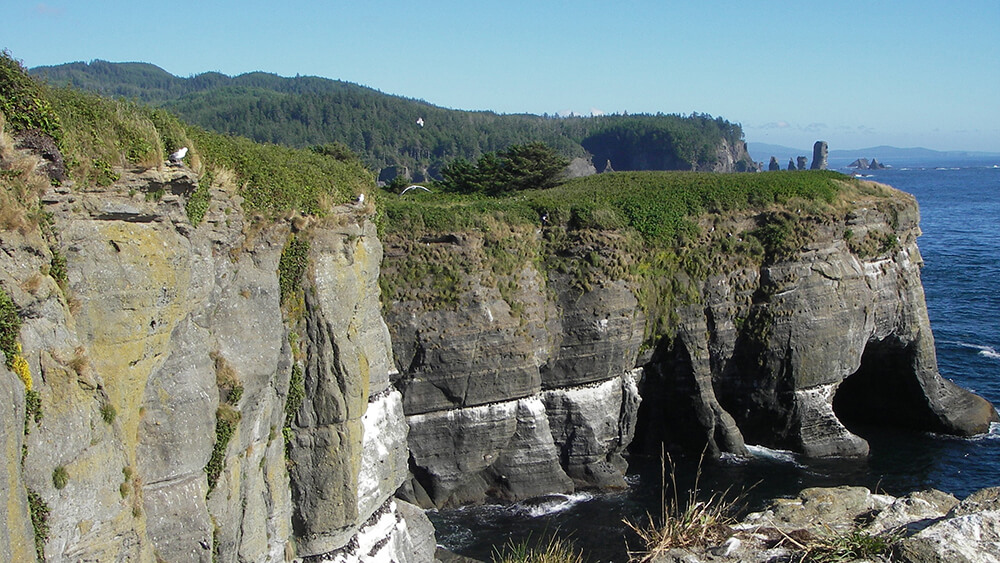
Broad beaches with various grain sizes (e.g., sand, gravel, cobble), dunes, and ridges dominate the Washington coastline from Cape Disappointment, on the north side of the Columbia River mouth, to the Hoh River. Wave action has eroded the shoreline through time and has formed steep cliffs at various places along the coast, and forested hills and sloping terraces are found near river mouths. Between Point Grenville and Cape Flattery, rocky cliffs can rise abruptly 50 to 300 feet above a wave-cut platform that is underwater except during extreme low tides. This wave-cut platform can be almost 2 miles wide in some places. Small islands, sea stacks, and rocks dot the platform’s surface.
References
Battista, T., Buja, K., Christensen, J., Hennessey, J., & Lassiter, K. (2017). Prioritizing seafloor mapping for Washington’s Pacific coast. Sensors, 17(4), 701.